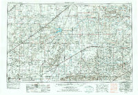
1954 Map of Perryton
USGS Topo · Published 1977About this map
Guymon and the surrounding High Plains of the Oklahoma Panhandle are defined by a grid of agricultural development and the vital corridors of the Chicago Rock Island and Pacific and the Atchison Topeka and Santa Fe railroads. This mid-century landscape reveals a region balancing heavy industrial presence with conservation, most notably at the Optima National Wildlife Refuge and Optima State Park along the Beaver River. Natural terrain features such as Sharp Dunes and Wild Horse Lake break the regularity of the section lines, while numerous small settlements like Bryans Corner, Mocane, and Slapout serve as local anchors. The map also captures the educational infrastructure at College in Goodwell, illustrating the social hubs that supported these rural ranching and farming communities during a period of steady growth.
Find a feature on this map
85 named features on this map. Tap any name to fly to it.
Don’t see what you’re looking for? This feature index may not catch every label — zoom into the map to look around manually.
Map Details
Editions of this 1954 Perryton Map
3 editions found
Other maps of this area

1892 · Meade
USGS Topo · 1:125,000

1892 · Vilas
USGS Topo · 1:125,000

1896 · Ashland
USGS Topo · 1:125,000

1953 · Stinnett Station
USGS Topo · 1:24,000

1953 · Pringle
USGS Topo · 1:24,000

1954 · Tucumcari
USGS Topo · 1:250,000

1954 · Perryton
USGS Topo · 1:250,000

1954 · Amarillo
USGS Topo · 1:250,000

1954 · Dalhart
USGS Topo · 1:250,000

1955 · Clinton
USGS Topo · 1:250,000