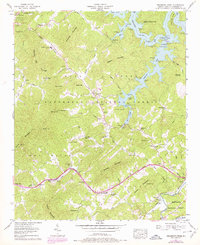
1957 Map of Persimmon Creek
USGS Topo · Published 1978About this map
Fields of the Wood dominates the northwestern corner of this Cherokee County landscape, featuring a large-scale installation of the Ten Commandments and an observation tower. This 1957 record, updated with 1970s aerial photography, documents a rugged interior within the Nantahala National Forest where the Hiwassee River and Hiwassee Lake create a sprawling aquatic network north of the Louisville and Nashville Railroad. The settlement patterns are scattered and tied to gap passages and creek valleys, including the small community at Friendship (Suit PO) and Hothouse.
Find a feature on this map
72 named features on this map. Tap any name to fly to it.
Don’t see what you’re looking for? This feature index may not catch every label — zoom into the map to look around manually.
Map Details
Editions of this 1957 Persimmon Creek Map
3 editions found
Other maps of this area

1888 · Ellijay
USGS Topo · 1:125,000

1892 · Ellijay
USGS Topo · 1:125,000

1893 · Murphy
USGS Topo · 1:125,000

1898 · Ellijay
USGS Topo · 1:125,000

1911 · Ellijay
USGS Topo · 1:125,000

1914 · Murphy
USGS Topo · 1:125,000

1934 · Murphy
USGS Topo · 1:24,000

1934 · Persimmon Creek
USGS Topo · 1:24,000

1934 · McDaniel Bald
USGS Topo · 1:24,000

1934 · Unaka
USGS Topo · 1:24,000