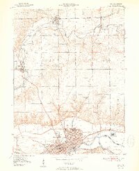
1951 Map of Peru
USGS Topo · Published 1951About this map
The confluence of the Wabash River and Mississinewa River anchors this mid-century survey, centered on the industrial and transport hub of Peru. A dense rail network including the Pennsylvania, New York Chicago and St Louis, and Chesapeake and Ohio railroads converges here, illustrating the city's role as a regional crossroads. To the south, the Circus City label hints at the area's deep ties to American entertainment history as a famous winter quarters for major shows.
Find a feature on this map
36 named features on this map. Tap any name to fly to it.
Don’t see what you’re looking for? This feature index may not catch every label — zoom into the map to look around manually.
Map Details
Editions of this 1951 Peru Map
2 editions found
Other maps of this area

1951 · Peru
USGS Topo · 1:24,000

1951 · Onward
USGS Topo · 1:24,000

1951 · Twelve Mile
USGS Topo · 1:24,000

1951 · Bunker Hill
USGS Topo · 1:24,000

1951 · Richvalley
USGS Topo · 1:24,000

1953 · Peoria
USGS Topo · 1:24,000

1953 · Danville
USGS Topo · 1:250,000

1953 · Muncie
USGS Topo · 1:250,000

1955 · Danville
USGS Topo · 1:250,000

1956 · Muncie
USGS Topo · 1:250,000