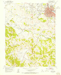
1953 Map of Petaluma
USGS Topo · Published 1955About this map
The city of Petaluma serves as the focal point of this mid-century survey, centered around its bustling rail and water transport corridors. The Northwestern Pacific railroad tracks parallel the winding path of Petaluma Creek, illustrating the town's historical role as a shipping hub for agricultural goods. The map shows the dense urban grid transitioning into expansive land grants and valleys, including San Antonio Valley and Hicks Valley.
Find a feature on this map
40 named features on this map. Tap any name to fly to it.
Don’t see what you’re looking for? This feature index may not catch every label — zoom into the map to look around manually.
Map Details
Editions of this 1953 Petaluma Map
3 editions found
Other maps of this area

1914 · Petaluma
USGS Topo · 1:62,500

1916 · Santa Rosa
USGS Topo · 1:62,500

1916 · Point Reyes
USGS Topo · 1:48,000

1918 · Point Reyes
USGS Topo · 1:62,500

1935 · Sebastopol
USGS Topo · 1:48,000

1942 · Sebastopol
USGS Topo · 1:62,500

1942 · Petaluma
USGS Topo · 1:62,500

1944 · Santa Rosa
USGS Topo · 1:62,500

1947 · Santa Rosa
USGS Topo · 1:250,000

1949 · Santa Rosa
USGS Topo · 1:250,000