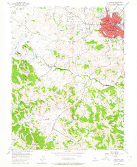
1953 Map of Petaluma
USGS Topo · Published 1964About this map
The Petaluma waterfront and its historic core serve as the anchor for this mid-century survey, where the Northwestern Pacific railroad tracks trace the eastern bank of the Petaluma River. The map captures a transitional landscape of urban density and outlying agricultural valleys, reaching into the ranch lands of Chileno Valley and Hicks Valley. Numerous country schoolhouses are documented throughout the hills, including Iowa School in the north and the Laguna Sch further south, marking the social centers of the rural landscape before post-war consolidation. The terrain is defined by prominent coastal peaks such as Antonio Mtn and Hicks Mtn, while the winding San Antonio Creek forms the natural boundary between Sonoma and Marin counties. Notable local landmarks like Cypress Hill Cemetery and the campus of St Vincents Sch provide fixed points for genealogical and historical research.
Find a feature on this map
44 named features on this map. Tap any name to fly to it.
Don’t see what you’re looking for? This feature index may not catch every label — zoom into the map to look around manually.
Map Details
Editions of this 1953 Petaluma Map
3 editions found
Other maps of this area

1914 · Petaluma
USGS Topo · 1:62,500

1916 · Santa Rosa
USGS Topo · 1:62,500

1916 · Point Reyes
USGS Topo · 1:48,000

1918 · Point Reyes
USGS Topo · 1:62,500

1935 · Sebastopol
USGS Topo · 1:48,000

1942 · Sebastopol
USGS Topo · 1:62,500

1942 · Petaluma
USGS Topo · 1:62,500

1944 · Santa Rosa
USGS Topo · 1:62,500

1947 · Santa Rosa
USGS Topo · 1:250,000

1949 · Santa Rosa
USGS Topo · 1:250,000