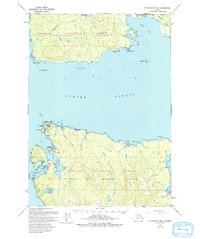
1949 Map of Petersburg B-5
USGS Topo · Published 1993About this map
Port Protection and Pt Baker anchor the northwestern coastline of Prince of Wales Island, serving as critical maritime outposts in the Tongass National Forest. This mapping, based on 1948 aerial photography with 1984 updates, captures the intricate shoreline of Sumner Strait where small settlements navigated a landscape of tidal inlets and dense timber. The topography reveals the isolation of the northern Alexander Archipelago, where life centered on protected harbors like Labouchere Bay and the navigational aid at West Rock Light. Across the water to the north, the southern tip of Kupreanof Island is defined by Totem Bay and the freshwater system of Kushneahin Lake. The presence of features like Hole-in-the-Wall and Joe Mace Island reflects the importance of small-vessel navigation in an era before extensive modern infrastructure reached these remote coastal reaches.
Find a feature on this map
39 named features on this map. Tap any name to fly to it.
Don’t see what you’re looking for? This feature index may not catch every label — zoom into the map to look around manually.
Map Details
Editions of this 1949 Petersburg B-5 Map
3 editions found
Other maps of this area

1948 · Petersburg A-6
USGS Topo · 1:63,360

1948 · Petersburg C-4
USGS Topo · 1:63,360

1948 · Petersburg B-6
USGS Topo · 1:63,360

1948 · Petersburg C-6
USGS Topo · 1:63,360

1948 · Petersburg C-5
USGS Topo · 1:63,360

1949 · Petersburg B-5
USGS Topo · 1:63,360

1949 · Petersburg A-5
USGS Topo · 1:63,360

1949 · Petersburg A-4
USGS Topo · 1:63,360

1949 · Petersburg B-4
USGS Topo · 1:63,360

1951 · Petersburg B-4
USGS Topo · 1:63,360