
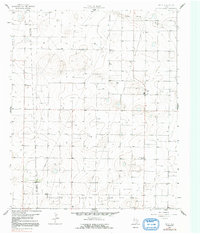
1965 Map of Pettit
USGS Topo · Published 1966About this map
Pettit and the surrounding agricultural lands of the High Plains are documented here during a period of significant petroleum extraction. The landscape is defined by the expansive Levelland and Slaughter Oil and Gas Field, where numerous well sites and pipelines interweave with the established section-line roads. This survey, conducted in the mid-1960s, captures the rural character of the Cochran and Hockley county line, where large-scale operations like Whiteface Farms managed the semi-arid terrain.
Find a feature on this map
7 named features on this map. Tap any name to fly to it.
Don’t see what you’re looking for? This feature index may not catch every label — zoom into the map to look around manually.
Map Details
Editions of this 1965 Pettit Map
2 editions found
Other maps of this area

1954 · Brownfield
USGS Topo · 1:250,000

1958 · Brownfield
USGS Topo · 1:250,000

1962 · Brownfield
USGS Topo · 1:250,000

1964 · Oklahoma Flat
USGS Topo · 1:24,000

1964 · Pep
USGS Topo · 1:24,000

1965 · Levelland West
USGS Topo · 1:24,000

1965 · Hester Ranch
USGS Topo · 1:24,000

1965 · Whiteface
USGS Topo · 1:24,000

1970 · Whiteface SW
USGS Topo · 1:24,000

1971 · Whiteface NW
USGS Topo · 1:24,000