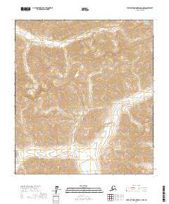
2017 Map of Philip Smith Mountains A-3 NW
USGS Topo · Published 2017About this map
The Philip Smith Mountains dominate this high-altitude Alaskan landscape, where steep contour lines describe the extreme relief of the North Slope. This 2017 survey by the U.S. Geological Survey maps a region defined by its hydrography and remote terrain, most notably the winding path of Your Creek (also labeled as Your Cr) as it flows through the mountain valleys. The map is primarily organized by the Public Land Survey System, showing several township and range boundaries such as t14s r15e and t15s r15e. The scarcity of man-made structures or roads emphasizes the wilderness character of this part of the North Slope Borough, where natural drainages and topographic peaks remain the primary landmarks for navigation and land management.
Find a feature on this map
9 named features on this map. Tap any name to fly to it.
Don’t see what you’re looking for? This feature index may not catch every label — zoom into the map to look around manually.
Map Details
Editions of this 2017 Philip Smith Mountains A-3 NW Map
This is the sole edition of this map. No revisions or reprints were ever made.
Other maps of this area

1951 · Brooks
USGS Topo · 1:250,000

1956 · Philip Smith Mountains
USGS Topo · 1:250,000

1964 · Philip Smith Mountains
USGS Topo · 1:250,000
1971 · Philip Smith Mountains A-4
USGS Topo · 1:63,360

1971 · Philip Smith Mountains B-3
USGS Topo · 1:63,360
1971 · Philip Smith Mountains B-4
USGS Topo · 1:63,360
1971 · Philip Smith Mountains A-3
USGS Topo · 1:63,360
2017 · Philip Smith Mountains B-3 SW
USGS Topo · 1:25,000
2017 · Philip Smith Mountains A-4 NE
USGS Topo · 1:25,000
2017 · Philip Smith Mountains B-4 SE
USGS Topo · 1:25,000