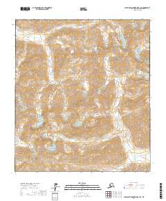
2017 Map of Philip Smith Mountains B-3 SE
USGS Topo · Published 2017About this map
The Middle Fork Chandalar River, also known by the Gwich'in name Teedriinjik River, dominates this mountainous landscape in the Brooks Range. This section of the North Slope reflects a remote wilderness environment where high-altitude relief and river drainages provide the primary geographic context. The dual naming of the river system on this 2017 survey highlights the integration of indigenous hydronyms alongside established colonial names, a significant detail for those studying the cartographic history of the Alaskan Arctic. The terrain is characterized by steep contours and glacial valleys, with the river serving as the central topographical feature through which the surrounding ridges are oriented.
Find a feature on this map
8 named features on this map. Tap any name to fly to it.
Don’t see what you’re looking for? This feature index may not catch every label — zoom into the map to look around manually.
Map Details
Editions of this 2017 Philip Smith Mountains B-3 SE Map
This is the sole edition of this map. No revisions or reprints were ever made.
Other maps of this area

1951 · Brooks
USGS Topo · 1:250,000

1956 · Philip Smith Mountains
USGS Topo · 1:250,000

1964 · Philip Smith Mountains
USGS Topo · 1:250,000
1971 · Philip Smith Mountains A-2
USGS Topo · 1:63,360

1971 · Philip Smith Mountains B-3
USGS Topo · 1:63,360
1971 · Philip Smith Mountains A-3
USGS Topo · 1:63,360
1971 · Philip Smith Mountains B-2
USGS Topo · 1:63,360
2017 · Philip Smith Mountains A-2 NW
USGS Topo · 1:25,000
2017 · Philip Smith Mountains B-2 SW
USGS Topo · 1:25,000
2017 · Philip Smith Mountains B-2 NW
USGS Topo · 1:25,000