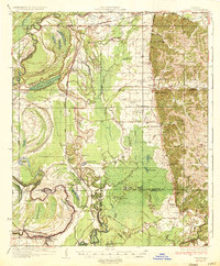
1935 Map of Philipp
USGS Topo · Published 1935About this map
Tippo Bayou and the Tallahatchie River wind through this mid-1930s landscape of the Mississippi Delta, where extensive Levee systems and oxbow lakes like Fish Lake and Hampton Lake define the bottomland. The Yazoo and Mississippi Valley RR provides a critical transportation spine, connecting small agricultural centers such as Philipp and Locopolis. The map reveals a dense network of local institutions, including the Whole Truth Ch, Lakeside Ch, and the Rosenwald Sch, reflecting the community structure of the era. To the east, the terrain rises toward Stonefield Hill and Dogwood Flats, where the Tallahatchie Boy Scout Camp is located near the Tallahatchie and Grenada county line. The distribution of schools like Holly Grove Sch and Cowart Sch illustrates the rural settlement patterns before modern consolidation.
Find a feature on this map
93 named features on this map. Tap any name to fly to it.
Don’t see what you’re looking for? This feature index may not catch every label — zoom into the map to look around manually.
Map Details
Editions of this 1935 Philipp Map
2 editions found
Other maps of this area

1931 · Schlater
USGS Topo · 1:48,000

1931 · Sumner
USGS Topo · 1:48,000

1932 · Philipp
USGS Topo · 1:48,000

1932 · Tutwiler
USGS Topo · 1:48,000

1934 · Schlater
USGS Topo · 1:62,500

1935 · Crowder
USGS Topo · 1:62,500

1935 · Sumner
USGS Topo · 1:62,500

1935 · Tutwiler
USGS Topo · 1:62,500

1935 · Philipp
USGS Topo · 1:62,500

1936 · Greenwood
USGS Topo · 1:62,500