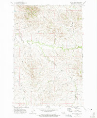
1972 Map of Phillip Spring
USGS Topo · Published 1975About this map
Phillip Spring and the intricate drainage system of Bennie Peer Creek characterize this corner of McKenzie County, North Dakota. The landscape is defined by a network of seasonal draws and perennial springs that historically dictated the movement of cattle and homesteaders across this semi-arid terrain. Numerous wells and a drill hole are scattered throughout the sections, reflecting the early 1970s push for water and mineral exploration in the Badlands. The terrain rises to Mc Peak, while isolated water sources like Klandt Spring and Mc Peak Spring provide critical landmarks in the upland breaks. A solitary Jeep Trail winds through the northern sections, marking one of the few improved paths across the draws and ridges that feed into One-O-One Creek.
Find a feature on this map
17 named features on this map. Tap any name to fly to it.
Don’t see what you’re looking for? This feature index may not catch every label — zoom into the map to look around manually.
Map Details
Editions of this 1972 Phillip Spring Map
This is the sole edition of this map. No revisions or reprints were ever made.
Other maps of this area

1909 · Glendive
USGS Topo · 1:250,000

1953 · Watford City
USGS Topo · 1:250,000

1954 · Glendive
USGS Topo · 1:250,000

1957 · Glendive
USGS Topo · 1:250,000

1957 · Watford City
USGS Topo · 1:250,000

1958 · Glendive
USGS Topo · 1:250,000

1966 · Sidney NE
USGS Topo · 1:24,000

1967 · Watford City
USGS Topo · 1:250,000

1972 · Horse Creek School
USGS Topo · 1:24,000

1972 · Sidney SE
USGS Topo · 1:24,000