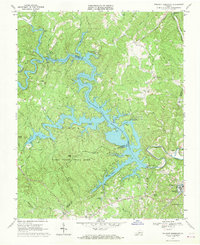
1967 Map of Philpott Reservoir
USGS Topo · Published 1969About this map
Philpott Reservoir dominates this landscape along the border of Franklin, Patrick, and Henry counties, where the Smith River was impounded by the Philpott Dam. Completed years prior to this 1967 field check, the reservoir's deeply crenulated shoreline creates distinctive features like Horseshoe Point, Turkey Island, and Goose Point. The western portion of the map is largely occupied by Fairy Stone State Park, featuring Stone Lake and Stuarts Knob. To the east, the industrial character of Bassett and West Bassett is evident, situated along the Norfolk and Western rail line. Smaller settlements and crossroads like Dodson, Prilliman, and the village of Philpott provide points of reference for genealogists. The map also records numerous country churches and cemeteries, such as Union Ch and Mt Hermon Ch, reflecting the area's rural social fabric.
Find a feature on this map
62 named features on this map. Tap any name to fly to it.
Don’t see what you’re looking for? This feature index may not catch every label — zoom into the map to look around manually.
Map Details
Editions of this 1967 Philpott Reservoir Map
Other maps of this area

1924 · Martinsville
USGS Topo · 1:48,000

1925 · Rocky Mount
USGS Topo · 1:48,000

1926 · Martinsville
USGS Topo · 1:62,500

1926 · Critz
USGS Topo · 1:48,000

1927 · Rocky Mount
USGS Topo · 1:62,500

1927 · Martinsville
USGS Topo · 1:62,500

1928 · Critz
USGS Topo · 1:62,500

1944 · Martinsville
USGS Topo · 1:62,500

1944 · Rocky Mount
USGS Topo · 1:62,500

1953 · Winston-Salem
USGS Topo · 1:250,000