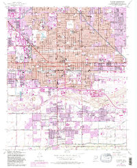
1952 Map of Phoenix
USGS Topo · Published 1983About this map
Phoenix undergoes a significant mid-century expansion in this record of its civic and industrial core. The landscape is defined by the Salt River valley, where an intricate system of irrigation including the Grand Canal and Western Canal supported the city's agricultural roots before rapid post-war urbanization took hold. This survey documents the concentration of state power at the Capitol Bldg and the emergence of Phoenix Sky Harbor International Airport as a regional hub. Local history is deeply etched into the grid, from the cluster of resting places like Greenwood Cem and Old City Cem to the numerous neighborhood institutions such as Carver High Sch and Kenilworth School. The map illustrates the transition from a desert rail center served by the Southern Pacific to a modernizing metropolis, with later purple revisions showing the outward creep of residential development.
Find a feature on this map
107 named features on this map. Tap any name to fly to it.
Don’t see what you’re looking for? This feature index may not catch every label — zoom into the map to look around manually.
Map Details
Editions of this 1952 Phoenix Map
5 editions found

Other maps of this area

1904 · Camelback
USGS Topo · 1:62,500

1906 · Camelsback
USGS Topo · 1:62,500

1912 · Phoenix
USGS Topo · 1:62,500

1913 · Mesa
USGS Topo · 1:62,500

1914 · Phoenix
USGS Topo · 1:62,500

1915 · Mesa
USGS Topo · 1:62,500

1930 · Cave Creek
USGS Topo · 1:125,000

1939 · Cave Creek
USGS Topo · 1:125,000

1952 · Tempe
USGS Topo · 1:24,000

1952 · Lone Butte
USGS Topo · 1:24,000