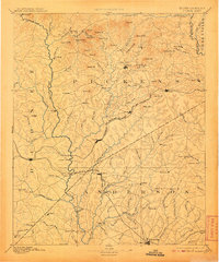
1894 Map of Pickens
USGS Topo · Published 1907About this map
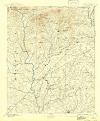
Pickens and the surrounding Upcountry landscape appear here as they were surveyed in the mid-1880s, characterized by a complex network of river crossings and small post offices. The Keowee River and Seneca River serve as primary geographical anchors, with notable historical transit points such as Cherry Ferry, Ravenel Bridge, and Earle Bridge facilitating movement between settlements. The interior is dotted with early community hubs like Six Mile P.O., Praters P.O., and Old Pickens, reflecting a rural economy dependent on local infrastructure.
Find a feature on this map
123 named features on this map. Tap any name to fly to it.
Don’t see what you’re looking for? This feature index may not catch every label — zoom into the map to look around manually.
Map Details
Editions of this 1894 Pickens Map
6 editions found
Other maps of this area

1886 · Walhalla
USGS Topo · 1:125,000

1888 · Pickens
USGS Topo · 1:125,000

1891 · Cowee
USGS Topo · 1:125,000

1891 · Carnesville
USGS Topo · 1:125,000

1892 · Walhalla
USGS Topo · 1:125,000

1892 · Abbeville
USGS Topo · 1:125,000

1893 · Elberton
USGS Topo · 1:125,000

1894 · Pickens
USGS Topo · 1:125,000

1896 · Walhalla
USGS Topo · 1:125,000

1897 · Cowee
USGS Topo · 1:125,000