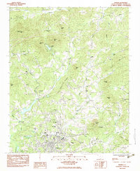
1983 Map of Pickens
USGS Topo · Published 1983About this map
The street grid of Pickens serves as the focal point of this 1983 survey, situated south of the numerous peaks and ridges of the Blue Ridge foothills. Numerous small rural congregations and cemeteries are scattered throughout the countryside, including Crescent Hill Ch, Porter Chapel, and Bethany Ch. The landscape is defined by its dramatic relief, with named heights like Glassy Mtn, Walnut Cove Mtn, and Fox Squirrel Ridge overlooking the waterways of Twelvemile Creek and the Oolenoy River. A notable concentration of community centers such as Ambler Sch and various churches near the northern settlement of Oolenoy illustrate the established social fabric of the county during the early 1980s. The presence of specialized infrastructure, such as the Sewage Disposal Pond and Water Plant, indicates the modernization of local utilities during this era.
Find a feature on this map
49 named features on this map. Tap any name to fly to it.
Don’t see what you’re looking for? This feature index may not catch every label — zoom into the map to look around manually.
Map Details
Editions of this 1983 Pickens Map
2 editions found
Other maps of this area

1888 · Pickens
USGS Topo · 1:125,000

1894 · Pickens
USGS Topo · 1:125,000

1905 · Pisgah
USGS Topo · 1:125,000

1906 · Pisgah
USGS Topo · 1:125,000

1935 · Eastatoe Gap
USGS Topo · 1:24,000

1935 · Table Rock
USGS Topo · 1:24,000
1946 · Eastatoe Gap
USGS Topo · 1:24,000
1946 · Table Rock
USGS Topo · 1:24,000
1947 · Eastatoe Gap
USGS Topo · 1:24,000
1947 · Table Rock
USGS Topo · 1:24,000