
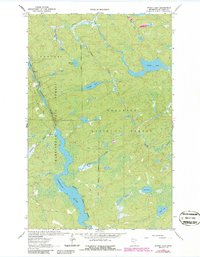
1963 Map of Picket Lake
USGS Topo · Published 1965About this map
The Vermilion River snakes through a landscape defined by its transition between protected timberlands in the early 1960s. This survey illustrates the convergence of the Kabetogama State Forest and the Superior National Forest, highlighting a region shaped by glacial hydrology. Small, secluded water bodies like Mankus Lake, Finstad Lake, and Lake Lon are connected by a network of drainages including Hilda Creek and Finstad Creek. Evidence of local extraction is visible at a Gravel Pit near the riverbanks, though the area remains largely undeveloped, characterized by the dense contours of northern Minnesota's lake country. The detailed soundings provided by the Minnesota Department of Conservation offer a rare glimpse into the underwater topography of the river's wider reaches, such as Kabetogama.
Find a feature on this map
17 named features on this map. Tap any name to fly to it.
Don’t see what you’re looking for? This feature index may not catch every label — zoom into the map to look around manually.
Map Details
Editions of this 1963 Picket Lake Map
2 editions found
Other maps of this area

1954 · Hibbing
USGS Topo · 1:250,000

1954 · International Falls
USGS Topo · 1:250,000

1956 · Sioux Pine Island
USGS Topo · 1:24,000

1956 · Vermilion Dam
USGS Topo · 1:24,000

1957 · Hibbing
USGS Topo · 1:250,000

1957 · International Falls
USGS Topo · 1:250,000

1958 · International Falls
USGS Topo · 1:250,000

1958 · Hibbing
USGS Topo · 1:250,000

1963 · Echo Lake
USGS Topo · 1:24,000

1963 · Astrid Lake
USGS Topo · 1:24,000