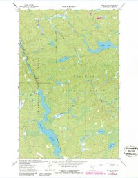
1963 Map of Picket Lake
USGS Topo · Published 1986About this map
Vermilion River dominates this north-woods landscape, winding through a complex network of wetlands and dense forest where the Superior National Forest meets the Kabetogama State Forest. This mid-century survey, updated in the 1980s, captures a wilderness area defined by its hydrology rather than its infrastructure. Deep in St. Louis County, the map details numerous named water bodies including Picket Lake, Mankus Lake, and Finstad Lake, many connected by a web of drainages like Picket Creek and Finstad Creek. Beyond the water, the terrain is marked by few human interventions, notably a single Gravel Pit and scattered benchmarks like BM 1296. The presence of various Rapids along the river illustrates the unchanged nature of these northern waterways, providing a baseline for environmental historians and those tracing the boundaries of Minnesota's vast public forest lands.
Find a feature on this map
22 named features on this map. Tap any name to fly to it.
Don’t see what you’re looking for? This feature index may not catch every label — zoom into the map to look around manually.
Map Details
Editions of this 1963 Picket Lake Map
2 editions found

Other maps of this area

1954 · Hibbing
USGS Topo · 1:250,000

1954 · International Falls
USGS Topo · 1:250,000

1956 · Sioux Pine Island
USGS Topo · 1:24,000

1956 · Vermilion Dam
USGS Topo · 1:24,000

1957 · Hibbing
USGS Topo · 1:250,000

1957 · International Falls
USGS Topo · 1:250,000

1958 · International Falls
USGS Topo · 1:250,000

1958 · Hibbing
USGS Topo · 1:250,000

1963 · Echo Lake
USGS Topo · 1:24,000

1963 · Astrid Lake
USGS Topo · 1:24,000