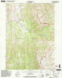
1996 Map of Pickle Pass
USGS Topo · Published 1998About this map
Grayback Ridge and the Teton Range converge in this high-elevation region of western Wyoming, where the headwaters of the Greys River and the Little Greys River define the local topography. This 1996 survey illustrates the remote intersection of the Bridger National Forest and Teton National Forest, showing a landscape primarily managed for recreation and resource protection. A specialized Hunting Camp and a Trailhead Parking Lot indicate seasonal human activity, while the presence of the Stewart Trail and several 4wd routes reflect the essential infrastructure for navigating the mountainous terrain. Local landmarks such as Mc Cain Spring and a specific Water Trough highlight the importance of water sources for both wildlife and livestock in the backcountry. Boundary lines for the Jackson District and Big Piney District intersect near the namesake Pickle Pass, marking the administrative divisions that shaped land use during the late twentieth century.
Find a feature on this map
33 named features on this map. Tap any name to fly to it.
Don’t see what you’re looking for? This feature index may not catch every label — zoom into the map to look around manually.
Map Details
Editions of this 1996 Pickle Pass Map
2 editions found
Other maps of this area

1921 · Afton
USGS Topo · 1:125,000

1931 · Jackson
USGS Topo · 1:125,000

1935 · Jackson
USGS Topo · 1:125,000

1955 · Driggs
USGS Topo · 1:250,000

1955 · Preston
USGS Topo · 1:250,000

1958 · Driggs
USGS Topo · 1:250,000

1958 · Preston
USGS Topo · 1:250,000

1962 · Driggs
USGS Topo · 1:250,000

1962 · Preston
USGS Topo · 1:250,000

1965 · Pickle Pass
USGS Topo · 1:24,000