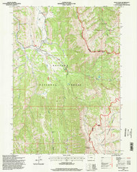
1996 Map of Pickle Pass
USGS Topo · Published 1998About this map
Grayback Ridge and Middle Ridge dominate this high-altitude landscape within the Bridger National Forest and Teton National Forest. The 1996 update reveals a network of water resources and mountain passes vital for navigation in this wilderness, including Pickle Pass and Telephone Pass. Water features such as Mc Cain spring and a Water Trough near the northern boundary point to land use patterns involving livestock or early resource management. The convergence of the Greys River and Little Greys River creates a primary drainage system, supported by numerous smaller tributaries like Stewart Creek and Blind Bull Creek. Significant human infrastructure is limited to the Stewart Creek Trail and Telephone Hollow Trail, alongside a Hunting Camp and Trailhead Parking Lot, illustrating the area's primary role as a managed forest and recreational corridor.
Find a feature on this map
28 named features on this map. Tap any name to fly to it.
Don’t see what you’re looking for? This feature index may not catch every label — zoom into the map to look around manually.
Map Details
Editions of this 1996 Pickle Pass Map
2 editions found
Other maps of this area

1921 · Afton
USGS Topo · 1:125,000

1931 · Jackson
USGS Topo · 1:125,000

1935 · Jackson
USGS Topo · 1:125,000

1955 · Driggs
USGS Topo · 1:250,000

1955 · Preston
USGS Topo · 1:250,000

1958 · Driggs
USGS Topo · 1:250,000

1958 · Preston
USGS Topo · 1:250,000

1962 · Driggs
USGS Topo · 1:250,000

1962 · Preston
USGS Topo · 1:250,000

1965 · Pickle Pass
USGS Topo · 1:24,000