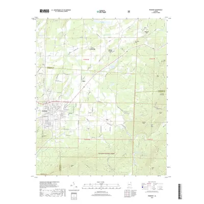
2018 Map of Piedmont
USGS Topo · Published 2018About this map
The city of Piedmont sits at the foot of the southern Appalachian ridges, serving as a hub where the valley floors meet the protected lands of the Talladega National Forest. This survey captures the transition between the developed street grid of the town center, including Memorial Garden Cem, and the rural outposts of Ladiga and Vigo. The landscape is defined by the northeast-to-southwest orientation of its ridges, such as Dugger Mtn and Choccolocco Mtn, which frame the paths of Terrapin Creek and Nances Creek. Local history is preserved in small family and community burial grounds like Goshen Cem and Ladiga Cem. The presence of the Pinhoti NRT trail following the high ground of Oakey Mtn and Wilson Ridge illustrates how this corner of Alabama balances its industrial and agricultural roots with modern conservation and recreation.
Find a feature on this map
110 named features on this map. Tap any name to fly to it.
Don’t see what you’re looking for? This feature index may not catch every label — zoom into the map to look around manually.
Map Details
Editions of this 2018 Piedmont Map
This is the sole edition of this map. No revisions or reprints were ever made.
Other maps of this area

1886 · Rome
USGS Topo · 1:125,000

1889 · Tallapoosa
USGS Topo · 1:125,000

1892 · Tallapoosa
USGS Topo · 1:125,000

1893 · Fort Payne
USGS Topo · 1:125,000

1897 · Tallapoosa
USGS Topo · 1:125,000

1898 · Rome
USGS Topo · 1:125,000

1898 · Fort Payne
USGS Topo · 1:125,000

1899 · Rome
USGS Topo · 1:125,000

1900 · Fort Payne
USGS Topo · 1:125,000

1900 · Anniston
USGS Topo · 1:125,000