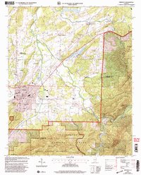
2001 Map of Piedmont
USGS Topo · Published 2004About this map
Piedmont sits at the intersection of industry and the landscape as of the turn of the 21st century, serving as a hub for both the surrounding agricultural crossroads and the timberlands of the Talladega National Forest. The map shows a transition from the urban grid of the city, featuring Bethune High Sch and the Paramount Memorial Garden Cem, to the protected heights of the Dugger Mountain Wilderness. To the north, the landscape is defined by the winding course of Terrapin Creek and small rural communities like Spring Garden and McFrey Crossroads. These smaller settlements are anchored by local institutions such as Philadelphia Ch and Spring Garden Sch. The presence of the Pinhoti Trail and multiple ridges like Chinquapin Ridge and Augusta Mine Ridge highlights the region's topography, which historically supported mining operations and remains a focal point for modern conservation.
Find a feature on this map
59 named features on this map. Tap any name to fly to it.
Don’t see what you’re looking for? This feature index may not catch every label — zoom into the map to look around manually.
Map Details
Editions of this 2001 Piedmont Map
This is the sole edition of this map. No revisions or reprints were ever made.
Other maps of this area

1886 · Rome
USGS Topo · 1:125,000

1889 · Tallapoosa
USGS Topo · 1:125,000

1892 · Tallapoosa
USGS Topo · 1:125,000

1893 · Fort Payne
USGS Topo · 1:125,000

1897 · Tallapoosa
USGS Topo · 1:125,000

1898 · Rome
USGS Topo · 1:125,000

1898 · Fort Payne
USGS Topo · 1:125,000

1899 · Rome
USGS Topo · 1:125,000

1900 · Fort Payne
USGS Topo · 1:125,000

1900 · Anniston
USGS Topo · 1:125,000