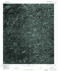
1975 Map of Piedmont SE
USGS Topo · Published 1977About this map
Coleman Lake sits at the heart of this mid-1970s orthophoto map, which provides a photographic look at the forested terrain of northern Cleburne County. The settlement patterns in this area are defined by small crossroads and linear developments along narrow ridge-top roads, a characteristic of the Appalachian foothills. This aerial-based survey, produced in cooperation with the Soil Conservation Service, documents the rural landscape before more recent reforestation and development altered the visibility of historical structures. The small community of Grantley is visible in the north, while the area around Liberty Hill showcases the winding road networks typical of this wooded region. Researchers can observe the exact density of timber and the footprint of small agricultural clearings that supported these local communities during the mid-twentieth century.
Find a feature on this map
3 named features on this map. Tap any name to fly to it.
Don’t see what you’re looking for? This feature index may not catch every label — zoom into the map to look around manually.
Map Details
Editions of this 1975 Piedmont SE Map
This is the sole edition of this map. No revisions or reprints were ever made.
Other maps of this area

1889 · Tallapoosa
USGS Topo · 1:125,000

1892 · Tallapoosa
USGS Topo · 1:125,000

1897 · Tallapoosa
USGS Topo · 1:125,000

1900 · Anniston
USGS Topo · 1:125,000

1953 · Atlanta
USGS Topo · 1:250,000

1954 · Choccolocco
USGS Topo · 1:24,000

1957 · Atlanta
USGS Topo · 1:250,000

1958 · Atlanta
USGS Topo · 1:250,000
1966 · Borden Springs
USGS Topo · 1:24,000
1966 · Oak Level
USGS Topo · 1:24,000