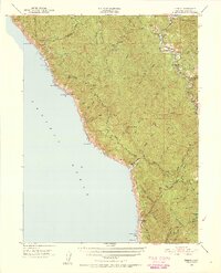
1950 Map of Piercy
USGS Topo · Published 1955About this map
The South Fork Eel River winds through the northern Mendocino coastline in this mid-century survey, a landscape defined by the timber-rich corridors of Jackass Ridge and Timber Ridge. The transportation network is dominated by the Redwood Highway, which connects the settlement of Piercy to the protected forests of Richardson Grove State Park. Notable family holdings like Medcalf Ranch and DeVilbiss Ranch indicate a pattern of rural land use that persisted even as earlier coastal outposts began to fade. This era of the map captures several locations in transition, specifically noting the Moody (Site) and Kenny (Site) as former settlements. To the west, the coastline is punctuated by navigational landmarks such as Needle Rock and Bear Harbor, where the steep terrain meets the Pacific Ocean at Anderson Cliffs.
Find a feature on this map
53 named features on this map. Tap any name to fly to it.
Don’t see what you’re looking for? This feature index may not catch every label — zoom into the map to look around manually.
Map Details
Editions of this 1950 Piercy Map
5 editions found

Other maps of this area

1920 · Pt. Delagda
USGS Topo · 1:62,500

1920 · Cummings
USGS Topo · 1:62,500

1920 · Harris
USGS Topo · 1:62,500

1921 · Westport
USGS Topo · 1:62,500

1921 · Briceland
USGS Topo · 1:62,500

1921 · Branscomb
USGS Topo · 1:62,500

1949 · Eureka
USGS Topo · 1:250,000

1949 · Alderpoint
USGS Topo · 1:62,500

1949 · Point Delgada
USGS Topo · 1:62,500

1949 · Garberville
USGS Topo · 1:62,500