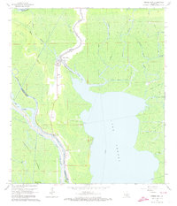
1966 Map of Pierre Part
USGS Topo · Published 1973About this map
Pierre Part serves as the focal point of this mid-1960s survey, situated where the Bayou Pierre Part and Little Bayou Pierre Part meet the sprawling waters of Lake Verret. The landscape is defined by an intricate network of waterways, including Grand Bayou and Bayou Alcide, alongside an extensive system of man-made structures like the Atchafalaya Floodway and several protective levees. The presence of the Intracoastal Waterway (Alternate Route) and names like Graveyard Island reflect the deep connection between the local economy and the swamp environment. Energy extraction is a dominant feature of the era, visible through the Pierre Pass Gas Field and the East Lake Verret Gas and Oil Field. Community life is anchored by landmarks such as Belle River Ch and Sacred Heart Ch, while industrial canals like the Westfield Canal and Godchaux Canal cut through the wetlands east of the lake.
Find a feature on this map
39 named features on this map. Tap any name to fly to it.
Don’t see what you’re looking for? This feature index may not catch every label — zoom into the map to look around manually.
Map Details
Editions of this 1966 Pierre Part Map
Other maps of this area

1935 · Chicot Lake
USGS Topo · 1:62,500

1936 · White Castle
USGS Topo · 1:62,500

1945 · New Orleans
USGS Topo · 1:250,000

1948 · Foster
USGS Topo · 1:62,500

1953 · Napoleonville
USGS Topo · 1:62,500

1954 · Chicot Lake
USGS Topo · 1:62,500

1954 · Baton Rouge
USGS Topo · 1:250,000
1955 · Chicot Lake
USGS Topo · 1:62,500

1956 · Baton Rouge
USGS Topo · 1:250,000

1959 · Foster
USGS Topo · 1:62,500