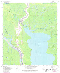
1966 Map of Pierre Part
USGS Topo · Published 1980About this map
Pierre Part sits at the heart of this Louisiana swamp landscape, where land and water merge into a complex network of bayous and passes. In the mid-1960s, this region was defined by its water-based economy and the expansive Lake Verret. The map captures the industrial character of the era with the Pierre Pass Gas Field and Bayou St Vincent Gas Field marked across the marshlands. Transportation follows the natural contours of the water, with the Intracoastal Waterway and the Belle River (Alternate Route) cutting through the basin. Local community life is anchored by landmarks like the Sacred Heart Ch and Belle River Ch, while the southern reaches reveal unique terrain features such as Graveyard Island. The intricate drainage patterns of Grand Bayou and Bayou Grosbec illustrate the seasonal nature of the Atchafalaya Floodway corridor.
Find a feature on this map
30 named features on this map. Tap any name to fly to it.
Don’t see what you’re looking for? This feature index may not catch every label — zoom into the map to look around manually.
Map Details
Editions of this 1966 Pierre Part Map
Other maps of this area

1935 · Chicot Lake
USGS Topo · 1:62,500

1936 · White Castle
USGS Topo · 1:62,500

1945 · New Orleans
USGS Topo · 1:250,000

1948 · Foster
USGS Topo · 1:62,500

1953 · Napoleonville
USGS Topo · 1:62,500

1954 · Chicot Lake
USGS Topo · 1:62,500

1954 · Baton Rouge
USGS Topo · 1:250,000
1955 · Chicot Lake
USGS Topo · 1:62,500

1956 · Baton Rouge
USGS Topo · 1:250,000

1959 · Foster
USGS Topo · 1:62,500