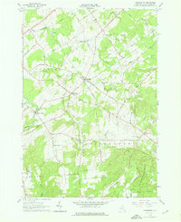
1964 Map of Pierrepont
USGS Topo · Published 1966About this map
Pierrepont and its surrounding hamlets define this mid-century view of St. Lawrence County, where the landscape transitions from the agricultural flats of Crary Mills to the wooded rises of the St Lawrence State Forest. The map documents a dense network of country roads, such as Waterman Hill Road and Howardville Road, connecting established community centers like Giffins Corners and Langdon Corners. In the southern reaches, the Little River winds near North Russell, while Waterman Hill provides a prominent topographic landmark above the local brooks and creeks.
Find a feature on this map
78 named features on this map. Tap any name to fly to it.
Don’t see what you’re looking for? This feature index may not catch every label — zoom into the map to look around manually.
Map Details
Editions of this 1964 Pierrepont Map
Other maps of this area

1908 · Potsdam
USGS Topo · 1:62,500

1910 · Canton
USGS Topo · 1:62,500

1911 · Canton
USGS Topo · 1:62,500

1915 · Russell
USGS Topo · 1:62,500

1918 · Russell
USGS Topo · 1:62,500

1921 · Stark
USGS Topo · 1:62,500

1923 · Stark
USGS Topo · 1:62,500

1940 · Stark
USGS Topo · 1:62,500

1943 · Potsdam
USGS Topo · 1:31,680
1943 · Colton
USGS Topo · 1:31,680