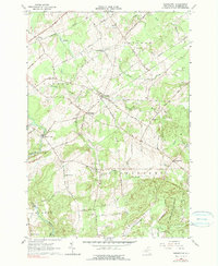
1964 Map of Pierrepont
USGS Topo · Published 1990About this map
Pierrepont and the rural townships of Canton and Potsdam characterize this mid-century landscape in St. Lawrence County. The settlement pattern is defined by small crossroads hamlets such as Crary Mills, Langdon Corners, and Howardville, many of which formed around early schoolhouses like Giffins Corners Sch and community churches including Brick Chapel. The New York Central railroad cuts through the northern section, tracing a path near Tracy Brook, while the southern reaches rise toward the higher elevations of Waterman Hill and the dense timber of the St Lawrence State Forest.
Find a feature on this map
66 named features on this map. Tap any name to fly to it.
Don’t see what you’re looking for? This feature index may not catch every label — zoom into the map to look around manually.
Map Details
Editions of this 1964 Pierrepont Map
Other maps of this area

1908 · Potsdam
USGS Topo · 1:62,500

1910 · Canton
USGS Topo · 1:62,500

1911 · Canton
USGS Topo · 1:62,500

1915 · Russell
USGS Topo · 1:62,500

1918 · Russell
USGS Topo · 1:62,500

1921 · Stark
USGS Topo · 1:62,500

1923 · Stark
USGS Topo · 1:62,500

1940 · Stark
USGS Topo · 1:62,500

1943 · Potsdam
USGS Topo · 1:31,680
1943 · Colton
USGS Topo · 1:31,680