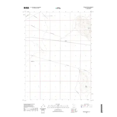
2020 Map of Pigeon Mountain
USGS Topo · Published 2020About this map
The high desert landscape of Pigeon and the Little Pigeon Mountains characterizes this section of western Box Elder County. Defined by its open terrain and isolated summits, the area features a network of rural routes such as Little Pigeon Rd and Pigeon Mountain Loop that skirt the base of Pigeon Mtn. A significant point of local interest is the presence of the Astronomical Observation Tunnels located in the western portion of the quadrangle. This suggests the area's utility for scientific observation or specialized environmental research, facilitated by the remote nature of the Great Salt Lake Desert region. Drainage across the flats is marked by the course of Grouse Cr, while the northern edge of the map is bordered by Lucin Airport Rd and Lucin Airport, indicating the vital transportation links that connect this sparsely populated territory.
Find a feature on this map
11 named features on this map. Tap any name to fly to it.
Don’t see what you’re looking for? This feature index may not catch every label — zoom into the map to look around manually.
Map Details
Editions of this 2020 Pigeon Mountain Map
This is the sole edition of this map. No revisions or reprints were ever made.
Other maps of this area

1954 · Brigham City
USGS Topo · 1:250,000

1958 · Brigham City
USGS Topo · 1:250,000

1962 · Brigham City
USGS Topo · 1:250,000
1967 · Pigeon Mountain
USGS Topo · 1:24,000
1967 · Lucin
USGS Topo · 1:24,000
1967 · Lucin NW
USGS Topo · 1:24,000
1967 · Lucin NE
USGS Topo · 1:24,000
1967 · Lemay Island
USGS Topo · 1:24,000
1967 · Crater Island NW
USGS Topo · 1:24,000

1983 · Jackson
USGS Topo · 1:24,000