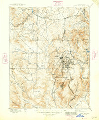
1901 Map of Pikes Peak
USGS Topo · Published 1948About this map
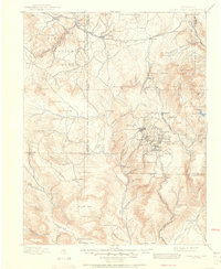
Pikes Peak anchors the eastern edge of this 1901 map, surveying the surrounding high country during the height of the Cripple Creek gold rush. The map reveals the intricate network of mining settlements that emerged at the end of the nineteenth century, including Cripple Creek, Victor, Goldfield, and Anaconda. The infrastructure required to support this industrial boom is clearly marked, with the Florence and Cripple Creek Railroad and the Midland Railroad winding through the terrain to connect these mountain towns to the outside world. To the north, the Manitou & Pikes Peak R. R. scales the slopes toward the summit, while lower-elevation locales like Florissant and Woodland Park provide a contrast to the dense mining districts. This survey also records paleontological significance at the Fossil Beds and identifies more transient landmarks such as Adelaide and Holbert Cabin.
Find a feature on this map
122 named features on this map. Tap any name to fly to it.
Don’t see what you’re looking for? This feature index may not catch every label — zoom into the map to look around manually.
Map Details
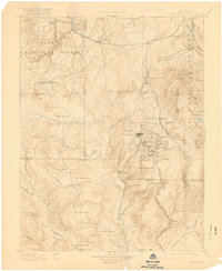
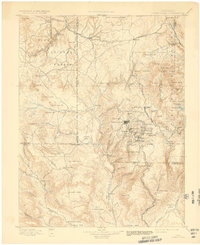
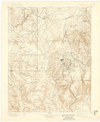
Editions of this 1901 Pikes Peak Map
6 editions found

Other maps of this area

1889 · Canon City
USGS Topo · 1:125,000

1891 · Pueblo
USGS Topo · 1:125,000

1892 · Canon City
USGS Topo · 1:125,000

1893 · Platte Canyon
USGS Topo · 1:125,000

1893 · Colorado Springs
USGS Topo · 1:125,000

1894 · Pikes Peak
USGS Topo · 1:125,000

1894 · Castle Rock
USGS Topo · 1:125,000

1894 · Pueblo
USGS Topo · 1:125,000

1896 · Pueblo
USGS Topo · 1:125,000

1897 · Pueblo
USGS Topo · 1:125,000