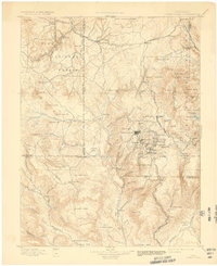
1901 Map of Pikes Peak
USGS Topo · Published 1932About this map
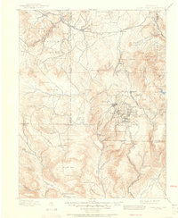
Cripple Creek sits at the heart of this gold mining district, surrounded by a dense cluster of supporting industrial settlements that defined the region’s boom years. The landscape is a network of mining towns including Victor, Goldfield, Anaconda, and Altman, each situated along the complex topography of Globe Hill and Big Bull Mt.. Transportation is dominated by the Colorado Midland Railroad to the north and the Florence and Cripple Creek R. R. winding through the canyons to the south, highlighting how central rail access was to the district's survival. To the northwest, the map captures the transition from industrial centers to the preserved natural history of the Fossil Beds near Florissant. From the high peaks of the Pike National Forest to the open flats of Eightmile Park, the survey documents a region where massive mineral wealth rapidly reshaped the mountainous terrain of Teller County.
Find a feature on this map
103 named features on this map. Tap any name to fly to it.
Don’t see what you’re looking for? This feature index may not catch every label — zoom into the map to look around manually.
Map Details
Editions of this 1901 Pikes Peak Map
6 editions found

Other maps of this area

1889 · Canon City
USGS Topo · 1:125,000

1891 · Pueblo
USGS Topo · 1:125,000

1892 · Canon City
USGS Topo · 1:125,000

1893 · Platte Canyon
USGS Topo · 1:125,000

1893 · Colorado Springs
USGS Topo · 1:125,000

1894 · Pikes Peak
USGS Topo · 1:125,000

1894 · Castle Rock
USGS Topo · 1:125,000

1894 · Pueblo
USGS Topo · 1:125,000

1896 · Pueblo
USGS Topo · 1:125,000

1897 · Pueblo
USGS Topo · 1:125,000