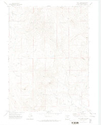
1971 Map of Pilot Knob
USGS Topo · Published 1974About this map
Routt National Forest dominates this landscape in the early 1970s, characterized by high elevations and resource extraction markers. The topography is defined by significant peaks such as Pilot Knob and Buck Mountain, with the central Anthracite Ridge suggesting a history of geological survey and potential coal prospecting. Human activity is sparsely recorded but notably represented by the Block Mine and a lone Drill Hole near the southern boundary.
Find a feature on this map
29 named features on this map. Tap any name to fly to it.
Don’t see what you’re looking for? This feature index may not catch every label — zoom into the map to look around manually.
Map Details
Editions of this 1971 Pilot Knob Map
2 editions found
Other maps of this area

1911 · Hahns Peak
USGS Topo · 1:125,000

1913 · Hahns Peak
USGS Topo · 1:125,000

1923 · Pilot Knob
USGS Topo · 1:62,500

1925 · Pilot Knob
USGS Topo · 1:62,500

1954 · Craig
USGS Topo · 1:250,000

1957 · Craig
USGS Topo · 1:250,000

1958 · Craig
USGS Topo · 1:250,000

1960 · Craig
USGS Topo · 1:250,000

1962 · Craig
USGS Topo · 1:250,000
1962 · Hahns Peak
USGS Topo · 1:24,000