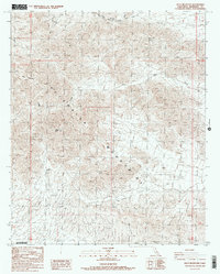
1986 Map of Pilot Mountain
USGS Topo · Published 1986About this map
Chuckwalla Mountains define this high-desert landscape in Riverside County, dominated by the prominent peak of Pilot Mountain. The area is characterized by an intricate network of dry drainage features, most notably Corn Wash and Ship Creek, which illustrate the complex topography surrounding Sharp Peak. Historically, the presence of Corn Springs highlights a critical water source in an otherwise arid environment, serving as a vital point for travelers and early inhabitants moving through these desert ranges. This 1986 provisional edition, based on earlier field checks and aerial photography, meticulously records the elevation contours and natural landmarks of the region during a period of ongoing geographic documentation by the U.S. Geological Survey.
Find a feature on this map
6 named features on this map. Tap any name to fly to it.
Don’t see what you’re looking for? This feature index may not catch every label — zoom into the map to look around manually.
Map Details
Editions of this 1986 Pilot Mountain Map
2 editions found
Other maps of this area

1940 · Iris Pass
USGS Topo · 1:62,500

1944 · Chuckwalla Mountains
USGS Topo · 1:62,500

1945 · Iris Pass
USGS Topo · 1:62,500

1952 · Sidewinder Well
USGS Topo · 1:62,500

1953 · Chuckwalla Spring
USGS Topo · 1:62,500

1954 · Salton Sea
USGS Topo · 1:250,000

1955 · Salton Sea
USGS Topo · 1:250,000

1959 · Salton Sea
USGS Topo · 1:250,000

1963 · Salton Sea
USGS Topo · 1:250,000
1963 · Iris Pass
USGS Topo · 1:62,500