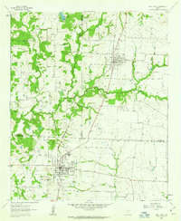
1961 Map of Pilot Point
USGS Topo · Published 1963About this map
The Texas and Pacific railroad forms the structural spine of this north Texas landscape, connecting the agricultural and residential hubs of Tioga and Pilot Point. During the early 1960s, these towns served as essential gathering points for the surrounding rural communities, evidenced by the dense concentration of civic institutions like Gee High Sch, Washington Sch, and St Thomas Sch. The survey documents a network of family and community landmarks, including Tipton Chapel and the Skinner Cem, set against a terrain defined by the winding course of Isle du Bois Creek and its many tributaries.
Find a feature on this map
28 named features on this map. Tap any name to fly to it.
Don’t see what you’re looking for? This feature index may not catch every label — zoom into the map to look around manually.
Map Details
Editions of this 1961 Pilot Point Map
3 editions found

Other maps of this area

1901 · Denison
USGS Topo · 1:125,000

1902 · Gainesville
USGS Topo · 1:125,000

1943 · Gainesville
USGS Topo · 1:125,000

1954 · Sherman
USGS Topo · 1:250,000

1958 · Whitesboro
USGS Topo · 1:62,500

1958 · Sherman
USGS Topo · 1:250,000

1960 · Green Valley
USGS Topo · 1:24,000

1960 · Celina
USGS Topo · 1:24,000

1960 · Aubrey
USGS Topo · 1:24,000

1960 · Woodbine
USGS Topo · 1:24,000