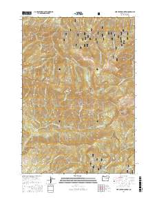
2017 Map of Pine Creek Mountain
USGS Topo · Published 2017About this map
Malheur National Forest dominates this section of the Blue Mountains, characterized by high ridges and deep drainage systems. The landscape is defined by massive topographic features like Yellow Jacket Ridge and Wall Creek Ridge, which separate various forks of the local creek systems. Water sources are frequent but localized, including high-altitude points like Halls Lake and several springs such as Anchor Spring and Deer Spring. The infrastructure is primarily composed of forest development roads, such as Natl Forest Develop Road 1430 Rd, which navigate the complex terrain. The map provides a clear look at the headwaters for several major drainages, including Pine Cr and Middle Fork Canyon Cr, showing how the mountain crests at Pine Creek Mtn and Spud Mtn dictate the flow of water through this wilderness area.
Find a feature on this map
48 named features on this map. Tap any name to fly to it.
Don’t see what you’re looking for? This feature index may not catch every label — zoom into the map to look around manually.
Map Details
Editions of this 2017 Pine Creek Mountain Map
This is the sole edition of this map. No revisions or reprints were ever made.
Other maps of this area

1940 · John Day
USGS Topo · 1:62,500

1943 · John Day
USGS Topo · 1:62,500

1955 · Canyon City
USGS Topo · 1:250,000

1959 · Canyon City
USGS Topo · 1:250,000

1959 · Prairie City
USGS Topo · 1:62,500

1961 · Logan Valley
USGS Topo · 1:62,500

1961 · Seneca
USGS Topo · 1:62,500

1972 · John Day
USGS Topo · 1:24,000

1972 · Canyon Mtn
USGS Topo · 1:24,000
1972 · Castle Creek
USGS Topo · 1:24,000