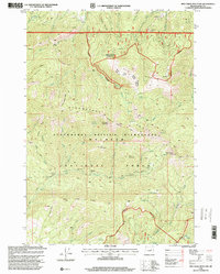
1998 Map of Pine Creek Mountain
USGS Topo · Published 2000About this map
Strawberry Mountain Wilderness dominates this portion of the Malheur National Forest, where steep ridgelines like Bear Skull Rims and Yellow Jacket Ridge define the drainage of the Strawberry Range. This late-twentieth-century survey documents a landscape defined by its mining history and remote forest camps. Mining activity is clustered in the northern reaches, notably at Dry Camp Mine, Chambers Mine, and Ray Mine, while scattered prospects mark the high slopes of Baldy Mountain.
Find a feature on this map
95 named features on this map. Tap any name to fly to it.
Don’t see what you’re looking for? This feature index may not catch every label — zoom into the map to look around manually.
Map Details
Editions of this 1998 Pine Creek Mountain Map
This is the sole edition of this map. No revisions or reprints were ever made.
Other maps of this area

1940 · John Day
USGS Topo · 1:62,500

1943 · John Day
USGS Topo · 1:62,500

1955 · Canyon City
USGS Topo · 1:250,000

1959 · Canyon City
USGS Topo · 1:250,000

1959 · Prairie City
USGS Topo · 1:62,500

1961 · Logan Valley
USGS Topo · 1:62,500

1961 · Seneca
USGS Topo · 1:62,500

1972 · John Day
USGS Topo · 1:24,000

1972 · Canyon Mtn
USGS Topo · 1:24,000
1972 · Castle Creek
USGS Topo · 1:24,000