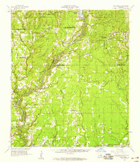
1958 Map of Pine Grove
USGS Topo · Published 1959About this map
The Amite River carves a winding path through this corner of Louisiana, serving as the natural boundary between East Baton Rouge Parish and Livingston Parish. During the mid-twentieth century, the landscape was a mix of small crossroads communities and rural institutions, including Camp Istrouma and a Girl Scout Camp situated near the river's bends. The area is dense with family-named landmarks and cemeteries such as Mahoney Cem, Womack Cem, and Friendship Ch Cem, reflecting deep-rooted settlement patterns. Significant transport relics like the Old Railroad Grade and Railroad Grade cut across the eastern terrain near Pine Grove, hinting at the region's logging or industrial past. From the established town of Denham Springs in the southwest to the quiet stations at Bluff Creek, the map details a world defined by its bayous, including Bayou Duplantier and Colyell Creek, and the small country churches that anchored these remote communities.
Find a feature on this map
103 named features on this map. Tap any name to fly to it.
Don’t see what you’re looking for? This feature index may not catch every label — zoom into the map to look around manually.
Map Details
Editions of this 1958 Pine Grove Map
3 editions found
Other maps of this area

1906 · Bayou Sara
USGS Topo · 1:125,000

1908 · Baton Rouge
USGS Topo · 1:62,500

1934 · Denham Springs
USGS Topo · 1:62,500

1934 · Springfield
USGS Topo · 1:62,500

1939 · Springfield
USGS Topo · 1:62,500

1939 · Zachary
USGS Topo · 1:62,500

1939 · Denham Springs
USGS Topo · 1:62,500

1939 · Baton Rouge
USGS Topo · 1:62,500

1941 · Gilead
USGS Topo · 1:31,680

1942 · Montpelier
USGS Topo · 1:31,680