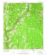
1958 Map of Pine Grove
USGS Topo · Published 1965About this map
The Amite River meanders through the heart of this mid-century landscape, defining the boundary between East Baton Rouge Parish and Livingston Parish. In the western reaches, Greenwell Springs Sanatorium stands near an ancient Indian Mound, marking a layer of much older human presence. Small settlements like Dennis Mills and Grangeville are connected by a network of rural roads, while the southern edge of the map shows the emerging development of Denham Springs and Walker. Long-established community life is visible through the many country churches and family burial grounds, such as Donald Chapel and Mullens Cem. The landscape reveals a transition from the Illinois Central rail corridor in the south to the more remote timber and agricultural lands of the north, where an Old Railroad Grade suggests the legacy of earlier logging operations.
Find a feature on this map
77 named features on this map. Tap any name to fly to it.
Don’t see what you’re looking for? This feature index may not catch every label — zoom into the map to look around manually.
Map Details
Editions of this 1958 Pine Grove Map
3 editions found
Other maps of this area

1906 · Bayou Sara
USGS Topo · 1:125,000

1908 · Baton Rouge
USGS Topo · 1:62,500

1934 · Denham Springs
USGS Topo · 1:62,500

1934 · Springfield
USGS Topo · 1:62,500

1939 · Springfield
USGS Topo · 1:62,500

1939 · Zachary
USGS Topo · 1:62,500

1939 · Denham Springs
USGS Topo · 1:62,500

1939 · Baton Rouge
USGS Topo · 1:62,500

1941 · Gilead
USGS Topo · 1:31,680

1942 · Montpelier
USGS Topo · 1:31,680