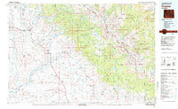
1981 Map of Pinedale
USGS Topo · Published 1982About this map
The Wind River Range dominates this 1981 survey, where the high alpine peaks of the Continental Divide meet the ranching valleys of the upper Green River basin. At the foot of the mountains, Pinedale and Boulder serve as hubs for a landscape defined by massive glacial lakes like Fremont Lake and Willow Lake. The map illustrates the complex intersection of federal and tribal lands, spanning the Bridger Wilderness and Shoshone National Forest into the western portion of the Wind River Indian Reservation.
Find a feature on this map
32 named features on this map. Tap any name to fly to it.
Don’t see what you’re looking for? This feature index may not catch every label — zoom into the map to look around manually.
Map Details
Editions of this 1981 Pinedale Map
3 editions found
Other maps of this area

1907 · Gros Ventre
USGS Topo · 1:125,000

1909 · Fremont Peak
USGS Topo · 1:125,000

1910 · Gros Ventre
USGS Topo · 1:125,000

1937 · Moccasin Lake
USGS Topo · 1:48,000

1938 · Mt Bonneville
USGS Topo · 1:62,500

1939 · Big Piney
USGS Topo · 1:125,000

1941 · Mt Bonneville
USGS Topo · 1:62,500

1942 · Big Piney
USGS Topo · 1:125,000

1942 · Mt Bonneville
USGS Topo · 1:62,500

1943 · Moccasin Lake
USGS Topo · 1:62,500