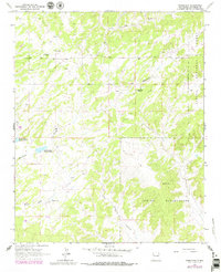
1963 Map of Pinehaven
USGS Topo · Published 1979About this map
The Zuni Indian Reservation and the Cibola National Forest meet in this high-desert landscape of McKinley County, defined by a network of drainage washes and historical landmarks. The map documents the community of Pinehaven, noting both the Pinehaven Cem and a site labeled as ruins, suggesting a shift in local habitation by the late 1970s. Religious and agricultural life is anchored by the Navajo Ch and the dual water resources of Vanderwagen Reservoir No 1 and Vanderwagen Reservoir No 2. Deeply carved terrain features like Coal Mine Canyon and Whitewater Arroyo illustrate the complex topography that governed movement through this region. This survey, updated with 1978 aerial data, provides a detailed look at the interface between tribal lands and national forest boundaries during a period of transition for rural New Mexico settlements.
Find a feature on this map
13 named features on this map. Tap any name to fly to it.
Don’t see what you’re looking for? This feature index may not catch every label — zoom into the map to look around manually.
Map Details
Editions of this 1963 Pinehaven Map
2 editions found
Other maps of this area

1886 · Wingate
USGS Topo · 1:250,000

1892 · Wingate
USGS Topo · 1:250,000

1954 · Gallup
USGS Topo · 1:250,000

1958 · Gallup
USGS Topo · 1:250,000

1959 · Gallup
USGS Topo · 1:250,000

1962 · Gallup
USGS Topo · 1:250,000

1963 · Twin Buttes
USGS Topo · 1:24,000

1963 · Pinehaven
USGS Topo · 1:24,000
1963 · Upper Nutria
USGS Topo · 1:24,000
1963 · Bread Springs
USGS Topo · 1:24,000