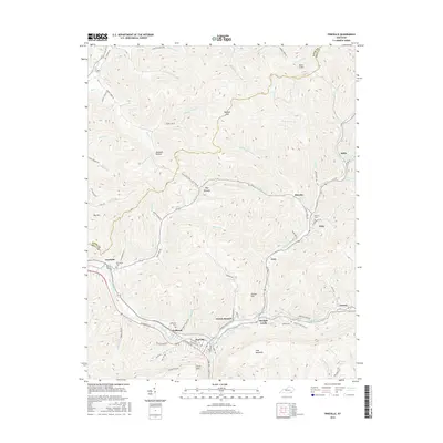
2016 Map of Pineville
USGS Topo · Published 2016About this map
Pine Mountain towers over the landscape where the Cumberland River cuts through the ridge, creating a natural gateway for the city of Pineville. This 2016 survey highlights the intricate network of hollows and ridges characteristic of Bell County, with settlements like Wallsend, Straight Creek, and Arjay tucked into the narrow valleys. The presence of numerous family and community burial grounds, such as Wallsend Cem and Red Hill Cem, provides significant value for genealogical research. Landmarks like Chain Rock and Toms Cliffs mark the high elevation points of the northern Cumberland Plateau. Local infrastructure is well-defined by roads tracing the creek beds, including Lewis Mine Rd and Old Dorton Branch Rd, which lead away from the river toward the smaller communities of Dorton Branch and Ivy Grove.
Find a feature on this map
84 named features on this map. Tap any name to fly to it.
Don’t see what you’re looking for? This feature index may not catch every label — zoom into the map to look around manually.
Map Details
Editions of this 2016 Pineville Map
This is the sole edition of this map. No revisions or reprints were ever made.
Other maps of this area

1886 · Cumberland Gap
USGS Topo · 1:125,000

1888 · Cumberland Gap
USGS Topo · 1:125,000

1891 · Cumberland Gap
USGS Topo · 1:125,000

1903 · Pineville
USGS Topo · 1:48,000

1903 · Middlesboro
USGS Topo · 1:48,000

1927 · Middlesboro
USGS Topo · 1:62,500

1930 · Middlesboro
USGS Topo · 1:62,500

1935 · Varilla
USGS Topo · 1:24,000

1952 · Fount
USGS Topo · 1:24,000
1952 · Artemus
USGS Topo · 1:24,000