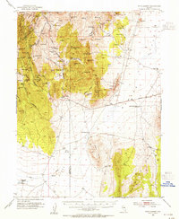
1953 Map of Pinto Summit
USGS Topo · Published 1955About this map
The Lincoln Highway cuts through the high desert terrain of central Nevada in this 1950s survey, marking a significant corridor of transit across Valley. The map reveals a landscape heavily shaped by mining activity, particularly in the northwest corner where the Bullwhacker Mine, Windfall Mine, and Eureka Tunnel indicate a legacy of resource extraction. Local infrastructure includes the County Hospital and a Tollhouse situated near the county line between Eureka Co and White Pine Co.
Find a feature on this map
107 named features on this map. Tap any name to fly to it.
Don’t see what you’re looking for? This feature index may not catch every label — zoom into the map to look around manually.
Map Details
Editions of this 1953 Pinto Summit Map
4 editions found
Other maps of this area

1926 · Roberts Mountains
USGS Topo · 1:250,000

1929 · Roberts Mountains
USGS Topo · 1:250,000

1951 · Green Springs
USGS Topo · 1:62,500

1951 · Pancake Summit
USGS Topo · 1:62,500

1953 · Pinto Summit
USGS Topo · 1:62,500

1953 · Eureka
USGS Topo · 1:62,500

1955 · Millett
USGS Topo · 1:250,000

1956 · Bellevue Peak
USGS Topo · 1:62,500

1956 · Cockalorum Wash
USGS Topo · 1:62,500

1956 · Whistler Mtn
USGS Topo · 1:62,500