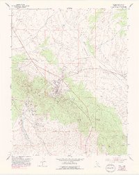
1953 Map of Pioche
USGS Topo · Published 1993About this map
Pioche sits at the heart of this Nevada mining district, where decades of silver and lead extraction shaped the high-desert landscape. The terrain is a dense network of industrial development, centered on the Pioche Hills and extending into Treasure Hill. A remarkable concentration of mining infrastructure is documented here, including the prominent Pioche Mines Mill Stack, the Raymond Ely Extension Mine, and the Pacific Tunnel. The layout reveals how the industry dictated settlement patterns, with the primary town site supported by outlying residential areas like Caselton and Caselton Heights.
Find a feature on this map
54 named features on this map. Tap any name to fly to it.
Don’t see what you’re looking for? This feature index may not catch every label — zoom into the map to look around manually.
Map Details
Editions of this 1953 Pioche Map
4 editions found
Other maps of this area

1885 · Pioche
USGS Topo · 1:250,000

1886 · Pioche
USGS Topo · 1:250,000

1915 · Bristol Range
USGS Topo · 1:62,500

1916 · Highland
USGS Topo · 1:62,500

1917 · Bristol Range
USGS Topo · 1:62,500

1918 · Highland
USGS Topo · 1:62,500

1921 · NW 1/4 Panaca
USGS Topo · 1:48,000

1953 · Highland Peak
USGS Topo · 1:24,000

1953 · Bristol Range SE
USGS Topo · 1:24,000

1953 · Pioche
USGS Topo · 1:24,000