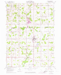
1961 Map of Pioneer
USGS Topo · Published 1974About this map
The village of Pioneer sits at the intersection of a complex drainage system where the Clear Fork and Silver Creek converge before reaching the St Joseph River further south. This 1961 survey, with 1973 revisions, documents the rural borderlands of Williams Co and Hillsdale County, showing the agricultural landscape that spans the Michigan-Ohio state line. The survey captures the town's spatial layout just before significant modernization, including the route of the Norfolk and Western railroad cutting through the southeast corner near Madison. Genealogists will find a concentrated cluster of historic burial sites and rural parishes, such as Floral Grove Cem, Drake Cem, and the Salem Ch. The presence of several Gravel Pits along the river branches points to the local extractive industry that supported the region's road and rail infrastructure.
Find a feature on this map
29 named features on this map. Tap any name to fly to it.
Don’t see what you’re looking for? This feature index may not catch every label — zoom into the map to look around manually.
Map Details
Editions of this 1961 Pioneer Map
Other maps of this area

1913 · Alvordton
USGS Topo · 1:62,500

1914 · Pioneer
USGS Topo · 1:62,500

1944 · Pioneer
USGS Topo · 1:62,500

1944 · Alvordton
USGS Topo · 1:62,500

1953 · Fort Wayne
USGS Topo · 1:250,000

1956 · Fort Wayne
USGS Topo · 1:250,000

1959 · Reading
USGS Topo · 1:24,000

1959 · Frontier
USGS Topo · 1:24,000
1961 · Pioneer
USGS Topo · 1:24,000
1961 · West Unity
USGS Topo · 1:24,000