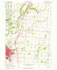
1961 Map of Piqua East
USGS Topo · Published 1962About this map
The industrial and riverfront city of Piqua anchors the southern portion of this 1961 survey, where the Baltimore and Ohio and Pennsylvania railroads intersect near the Miami River. This era shows a community in transition, with the prominent Miami and Erie Canal marked as abandoned, yet tracing a clear historical path through the landscape toward the Miami Conservancy District. Educational and religious life is well-documented through sites like Staunton St Sch and the Apostolic Gospel Temple.
Find a feature on this map
58 named features on this map. Tap any name to fly to it.
Don’t see what you’re looking for? This feature index may not catch every label — zoom into the map to look around manually.
Map Details
Editions of this 1961 Piqua East Map
4 editions found
Other maps of this area

1909 · Loramie
USGS Topo · 1:62,500

1911 · Loramie
USGS Topo · 1:62,500

1911 · Covington
USGS Topo · 1:62,500

1913 · Sidney
USGS Topo · 1:62,500

1914 · Troy
USGS Topo · 1:62,500

1944 · Covington
USGS Topo · 1:62,500

1944 · Sidney
USGS Topo · 1:62,500

1944 · Loramie
USGS Topo · 1:62,500

1944 · Troy
USGS Topo · 1:62,500

1953 · Muncie
USGS Topo · 1:250,000