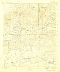
1921 Map of Piru
USGS Topo · Published 1927About this map
The Santa Clara River valley anchors this 1921 publication, where the Southern Pacific railroad connects established citrus and agricultural communities during the early 20th century. Settlement is concentrated along the river corridor and the parallel rail line, serving as the economic lifeline for towns like Fillmore and Piru. The map captures the distinct irrigation and land division patterns of the era, notably in Bardsdale and around Moorpark in the Little Simi Valley. To the north, the terrain transitions into the steep elevations of the Santa Barbara National Forest, where features like Oat Mtn and Hopper Mtn loom over the drainage of Little Sespe Creek. To the south, the landscape is defined by the Oak Ridge and Las Posas Hills, highlighting the natural barriers that funneled early transportation and ranching into specific valleys and canyons.
Find a feature on this map
63 named features on this map. Tap any name to fly to it.
Don’t see what you’re looking for? This feature index may not catch every label — zoom into the map to look around manually.
Map Details
Editions of this 1921 Piru Map
4 editions found
Other maps of this area

1900 · Triunfo Pass
USGS Topo · 1:62,500

1900 · Piru
USGS Topo · 1:62,500

1903 · Santa Paula
USGS Topo · 1:62,500

1903 · Calabasas
USGS Topo · 1:62,500

1903 · Mt. Pinos
USGS Topo · 1:125,000

1903 · Tejon
USGS Topo · 1:125,000

1903 · Camulos
USGS Topo · 1:125,000

1903 · Santa Susana
USGS Topo · 1:62,500

1904 · Hueneme
USGS Topo · 1:62,500

1921 · Piru
USGS Topo · 1:62,500