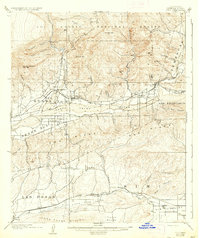
1921 Map of Piru
USGS Topo · Published 1937About this map
Fillmore and Piru anchor a landscape defined by the intersection of rail and river in the early twentieth century. This survey, updated from earlier field work, reveals a robust agricultural and transit corridor following the Santa Clara River and the Southern Pacific tracks. South of the river, Bardsdale and Epworth sit at the base of Oak Ridge, while the northern portion of the map is dominated by the canyons and peaks of the Los Padres National Forest, including Hopper Mtn and San Cayetano Mtn. The transport network is particularly detailed, showing the San Francisco Line and early road names like Santa Barbara. For local historians, the map preserves the location of smaller stops and settlements such as Sespe Sta., Buckhorn, and the historic Camulos estate, which are essential for tracing the development of Ventura County’s citrus and ranching communities.
Find a feature on this map
57 named features on this map. Tap any name to fly to it.
Don’t see what you’re looking for? This feature index may not catch every label — zoom into the map to look around manually.
Map Details
Editions of this 1921 Piru Map
4 editions found
Other maps of this area

1900 · Triunfo Pass
USGS Topo · 1:62,500

1900 · Piru
USGS Topo · 1:62,500

1903 · Santa Paula
USGS Topo · 1:62,500

1903 · Calabasas
USGS Topo · 1:62,500

1903 · Mt. Pinos
USGS Topo · 1:125,000

1903 · Tejon
USGS Topo · 1:125,000

1903 · Camulos
USGS Topo · 1:125,000

1903 · Santa Susana
USGS Topo · 1:62,500

1904 · Hueneme
USGS Topo · 1:62,500

1921 · Piru
USGS Topo · 1:62,500