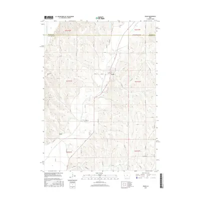
2015 Map of Pisgah
USGS Topo · Published 2015About this map
Pisgah serves as the central hub of this Missouri River valley region, situated where the Soldier River carves through the undulating loess hill topography of western Iowa. The landscape is defined by the sharp contrast between the flat alluvial plains of the Little Sioux River in the northwest and the intricate drainage network of Cobb Cr and Steer Cr to the south. Local history is anchored by sites like Fountainbleau Cem and Soldier Valley Cem, which provide significant points of interest for genealogical research. The road network, including Ia 183 and various county roads like Co HWY e60, follows the natural contours of the valley floors, illustrating how the area's geography has dictated transport and settlement patterns since the early 20th century.
Find a feature on this map
65 named features on this map. Tap any name to fly to it.
Don’t see what you’re looking for? This feature index may not catch every label — zoom into the map to look around manually.
Map Details
Editions of this 2015 Pisgah Map
This is the sole edition of this map. No revisions or reprints were ever made.
Other maps of this area

1954 · Omaha
USGS Topo · 1:250,000

1955 · Fremont
USGS Topo · 1:250,000

1957 · Fremont
USGS Topo · 1:250,000

1957 · Omaha
USGS Topo · 1:250,000

1958 · Omaha
USGS Topo · 1:250,000

1958 · Fremont
USGS Topo · 1:250,000

1970 · Little Sioux
USGS Topo · 1:24,000
1970 · Blencoe
USGS Topo · 1:24,000

1970 · Logan
USGS Topo · 1:24,000

1970 · Mondamin
USGS Topo · 1:24,000