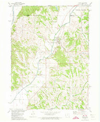
1971 Map of Pisgah
USGS Topo · Published 1974About this map
The Soldier River winds through the hills of Jackson and Magnolia townships, defining the landscape of this corner of Harrison and Monona counties. In the early 1970s, the town of Pisgah serves as the primary hub, situated near the river's bend and a local Gaging Station. The terrain is marked by sharp ridgelines and narrow valleys, such as Spring Valley, where numerous small tributaries like Allen Creek and Steer Creek drain the loess hills.
Find a feature on this map
18 named features on this map. Tap any name to fly to it.
Don’t see what you’re looking for? This feature index may not catch every label — zoom into the map to look around manually.
Map Details
Editions of this 1971 Pisgah Map
This is the sole edition of this map. No revisions or reprints were ever made.
Other maps of this area

1954 · Omaha
USGS Topo · 1:250,000

1955 · Fremont
USGS Topo · 1:250,000

1957 · Fremont
USGS Topo · 1:250,000

1957 · Omaha
USGS Topo · 1:250,000

1958 · Omaha
USGS Topo · 1:250,000

1958 · Fremont
USGS Topo · 1:250,000

1970 · Little Sioux
USGS Topo · 1:24,000
1970 · Blencoe
USGS Topo · 1:24,000

1970 · Logan
USGS Topo · 1:24,000

1970 · Mondamin
USGS Topo · 1:24,000