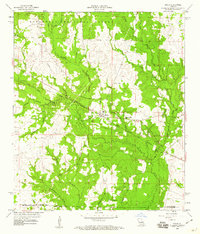
1959 Map of Pitkin
USGS Topo · Published 1960About this map
The Colorado and Santa Fe railroad corridor anchors this late-1950s survey of western Louisiana, cutting through the heart of Pitkin and the sprawling timberlands of the Kisatchie National Forest. This section of the state reveals a landscape transition where the piney woods meet a dense network of watercourses, including Sixmile Creek and the West Fork of the Calcasieu River. The settlement at Fullerton and the smaller community of Dido sit along these traditional transport and industry routes, reflecting the rural character of Vernon and Allen Parishes.
Find a feature on this map
35 named features on this map. Tap any name to fly to it.
Don’t see what you’re looking for? This feature index may not catch every label — zoom into the map to look around manually.
Map Details
Editions of this 1959 Pitkin Map
4 editions found
Other maps of this area

1941 · Slagle
USGS Topo · 1:62,500

1943 · Leander
USGS Topo · 1:62,500

1944 · Slagle
USGS Topo · 1:62,500

1947 · Steep Gully
USGS Topo · 1:31,680

1947 · Elizabeth
USGS Topo · 1:31,680

1947 · Grant
USGS Topo · 1:31,680

1947 · Sugartown
USGS Topo · 1:31,680

1947 · Sugrue
USGS Topo · 1:31,680

1947 · Pitkin
USGS Topo · 1:31,680

1948 · Grant
USGS Topo · 1:24,000