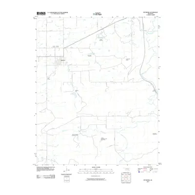
2010 Map of Pittsburg
USGS Topo · Published 2010About this map
Pittsburg serves as the central hub for this rural Oklahoma landscape, where the street grid of the settlement contrasts with the surrounding drainage networks of Chun Creek and Buck Creek. The area is characterized by numerous small-scale water management features, including the Storrie Lake Dam and the Pittsburg Dam, reflecting a landscape adapted for local water control. To the east, the Indian Nation Tpke cuts a modern path across the terrain, passing near the distinct geological formation of Limestone Ridge.
Find a feature on this map
27 named features on this map. Tap any name to fly to it.
Don’t see what you’re looking for? This feature index may not catch every label — zoom into the map to look around manually.
Map Details
Editions of this 2010 Pittsburg Map
This is the sole edition of this map. No revisions or reprints were ever made.
Other maps of this area

1898 · McAlester
USGS Topo · 1:125,000

1909 · Mc Alester
USGS Topo · 1:125,000

1950 · Mcalester
USGS Topo · 1:250,000

1957 · Limestone Gap
USGS Topo · 1:24,000

1962 · McAlester
USGS Topo · 1:250,000

1965 · McAlester
USGS Topo · 1:250,000

1967 · Pittsburg
USGS Topo · 1:24,000
1967 · Mc Alester SW
USGS Topo · 1:24,000
1967 · Kiowa
USGS Topo · 1:24,000

1967 · Hartshorne SW
USGS Topo · 1:24,000